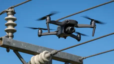

The vulnerability of electrical infrastructure to environmental decay has long necessitated dangerous manual inspections, but a recent breakthrough in the United Kingdom suggests that the era of human climbers may be nearing its end. This October, a significant milestone was reached when Team UAV, a specialized drone services provider, completed high-resolution aerial inspections of 500 pole-mounted transformers for National Grid Electricity Distribution. This initiative, funded through the Network Innovation Allowance, serves as a pivotal test case for whether artificial intelligence and computer vision can reliably identify physical deterioration on critical assets. By deploying sophisticated unmanned aerial vehicles, the project has successfully mapped out a new standard for monitoring the distribution network across the Midlands, South West England, and Wales. The focus remains on automating the detection of corrosion, which has historically been a labor-intensive process prone to human error and oversight.
Integrating Advanced Robotics into Electrical Maintenance
Technical Standardization: Enhancing Data Quality
To achieve a level of precision necessary for training machine learning algorithms, the technical standardization of the inspection process became a priority for the operational teams involved. Team UAV conducted extensive technical trials to establish precise camera angles and capture techniques that ensure every asset is documented with identical clarity. This methodical approach eliminated the variability typically found in manual ground-level photography or erratic flight paths, providing a clean dataset for subsequent analysis. By utilizing a custom Geographic Information System database, the crew linked every high-resolution image with specific asset metadata in real-time during the flight operations. This integration allowed for an unprecedented level of organization, where geographical coordinates and equipment specifications were immediately paired with visual evidence of wear. Such rigorous data discipline is the cornerstone of any successful transition toward automated asset management.
Practical Implementation: Scaling Regional Operations
The operational scope of this project spanned diverse geographies, including the rugged terrains of Cornwall and the mountainous regions of Wales, where access is often restricted. In these areas, traditional inspection methods require significant time and resources, often involving specialized vehicles or personnel navigating difficult landscapes on foot. Drone technology bypassed these physical barriers, allowing for rapid deployment and data retrieval without compromising the safety of utility workers or the surrounding environment. The ability to maintain a consistent distance from high-voltage equipment while capturing granular detail has proven essential for detecting micro-fractures and early-stage oxidation. By creating a uniform and repeatable data set, the project team ensured that the computer vision models received high-quality input across different lighting conditions and weather patterns. This geographical versatility underscores the potential for drones to serve the entire energy sector efficiently.
Scaling Digital Solutions for Grid Resilience
Software Integration: Developing Intelligent Systems
The collaboration extended beyond flight operations to include the development of sophisticated backend systems designed to interpret the massive influx of visual information. Softwire, a software firm, took on the task of building the artificial intelligence models and a prototype web application to process the imagery collected in the field. These models are specifically trained to recognize patterns of physical deterioration that might escape the naked eye of a tired inspector or be obscured by distance. By automating the condition assessment, the distribution network operator can now receive instant alerts regarding the health of pole-mounted transformers. This software layer serves as the connective tissue between raw aerial footage and actionable engineering insights, turning pictures into a prioritized maintenance schedule. The prototype application also provides a user-friendly interface for engineers to review flagged issues, ensuring that human expertise remains a vital check within the system.
Operational Insights: Building a Resilient Network
The collaborative efforts between Team UAV, Softwire, and National Grid Electricity Distribution established a clear precedent for the practical application of real-world artificial intelligence. Stakeholders recognized that the move toward automated inspections was a necessary evolution to ensure the stability of the energy sector in an increasingly digital landscape. Organizations seeking to replicate this success focused on the standardization of data collection and the development of robust software interfaces that complemented human decision-making. The transition from manual assessments to high-resolution aerial monitoring provided a more granular view of infrastructure health than was previously possible. By moving toward these digitized workflows, the industry addressed long-standing logistical challenges and improved the safety profiles of its field operations. Ultimately, the integration of drone technology and computer vision proved to be an essential step for utilities aiming to maintain complex, hard-to-reach assets effectively.