
The Indonesian archipelago presents a unique set of geographic challenges that demand a level of grid management sophistication rarely seen in other nations attempting large-scale energy transitions. Perusahaan Listrik Negara, the state-owned electric utility, is currently managing a network that serves approximately 96 million people across nearly 17,000 islands, necessitating a departure from traditional infrastructure management toward a more resilient digital framework. This shift is centered on the adoption of the ArcGIS Utility Network, which provides a comprehensive spatial foundation for what is being envisioned as a national super grid. By transitioning away from siloed data systems, the utility aims to create a singular, unified source of truth that integrates nearly one million circuit-kilometers of power lines into a responsive and intelligent ecosystem. This digital overhaul is not merely a software update but a fundamental reimagining of how energy is delivered and monitored in a modern economy.
Confronting the Limitations of Legacy Infrastructure
Modernizing such a vast and geographically dispersed infrastructure requires addressing the foundational issues that have historically limited the utility’s operational efficiency and responsiveness. For years, the reliance on localized systems created a fragmented view of the national grid, making it difficult to coordinate large-scale improvements or respond effectively to regional energy deficits. The move toward a centralized ArcGIS platform represents a strategic commitment to data integrity and organizational transparency, ensuring that all departments are aligned toward the same modernization goals. By establishing a unified spatial infrastructure, the utility is overcoming the logistical hurdles of managing thousands of islands and millions of assets. This transition is essential for creating the agility needed to support Indonesia’s rapid industrial growth and its ambitious goals for national electrification. The elimination of these technological barriers is the first step in building a grid that is not only robust but also capable of adapting to the shifting demands of a modern digital landscape.
Operational Hurdles: The Impact of Fragmented Data
One of the primary obstacles faced during the early stages of modernization was the pervasive inconsistency of asset information across different operational departments and regional units. Fragmented data architectures meant that maintenance crews and central planners often worked from conflicting records, leading to significant delays when identifying the source of localized power outages. Because the legacy system lacked a unified data model, simple queries regarding transformer capacity or circuit connectivity required hours of manual cross-referencing between physical maps and digital spreadsheets. This inefficiency not only increased the operational costs associated with routine maintenance but also slowed the utility’s response to emergency situations where time is of the essence. By consolidating these disparate information streams into a single spatial database, the utility has eliminated the guesswork that once plagued its field operations. Technicians now have access to verified, real-time data that ensures work orders are executed with precision.
Technical Constraints: Modeling Complex Grid Logic
Beyond data inconsistency, the legacy Geographic Information System was technically limited to basic point-to-line relationships, which restricted the ability to perform complex simulations. As the energy landscape in Indonesia grew more complex, the need for advanced switching simulations and automated outage detection became increasingly critical for maintaining long-term grid stability. The previous system lacked the mathematical logic required to handle the bidirectional power flows that are characteristic of modern energy environments, such as those incorporating residential solar installations. Without the capacity to model three-dimensional connectivity and phase information, engineers struggled to predict how localized changes would affect the broader network. The integration of a more sophisticated network model has provided the utility with the tools necessary to perform deep impact analyses and manage the integration of decentralized microgrids. This technical evolution ensures that the infrastructure remains capable of supporting the high reliability standards required for a growing population.
A Strategic Framework for Digital Transformation
Implementing a digital transformation of this magnitude necessitates a strategic framework that balances innovative technology with the practical realities of a large-scale workforce. The utility has adopted a structured approach to this migration, focusing on creating standardized workflows that can be replicated across its diverse operational units throughout the country. This framework ensures that as new capabilities are introduced, the organizational culture evolves in tandem, fostering a more data-driven approach to grid management. By prioritizing the development of a robust digital foundation, the utility is ensuring that its investments in technology yield measurable improvements in operational efficiency and customer service. This strategic planning involves close collaboration between internal engineering teams and external geospatial experts to ensure that every phase of the project is aligned with the national energy vision. The resulting roadmap provides a clear path forward for the utility to become a global leader in smart grid implementation and energy resilience.
Implementation Strategy: A Three-Stage Modernization Approach
The utility implemented a clear three-stage modernization framework to ensure that the transition to the new ArcGIS environment was both manageable and effective for its operational units. The first stage focused on pre-migration preparation, which involved cleaning and standardizing decades of historical data to ensure its compatibility with the intelligent network model. This was followed by a series of localized pilot programs in key urban areas, where the system’s advanced features were tested under real-world conditions to identify any potential technical gaps. These pilots provided valuable insights that were used to refine the technical workflows and data schemas before the national rollout commenced. The final stage involved scaling the system across the entire archipelago, supported by a comprehensive training program for thousands of employees to ensure the long-term sustainability of the platform. This methodical progression allowed the utility to maintain continuous service while building the internal capacity needed to manage a sophisticated digital power network.
Data Consolidation: Building the Core Asset Model
At the technical core of this transformation was an intensive effort to consolidate nearly one million circuit-kilometers of power lines into a streamlined and intelligent data model. By utilizing attribute domains and subtypes, the utility was able to condense a vast array of isolated feature classes into a core set of rule-based objects that accurately represent physical assets. This process involved defining the logical relationships between every piece of equipment, from high-voltage transmission towers down to individual residential meters. The resulting model does not just show where an asset is located; it understands how that asset functions within the larger network and how it relates to its neighbors. This level of intelligence is essential for performing advanced simulations, such as tracing the impact of a circuit breaker trip or calculating the capacity of a specific distribution line. By establishing this high-fidelity digital foundation, the utility has turned its GIS into the definitive source of truth, enabling more informed decision-making across all levels.
Driving Resilience and Connectivity in a Smart Grid
The realization of a connected network model has brought about a paradigm shift in how the utility perceives and manages its physical assets across the Indonesian archipelago. With the implementation of network intelligence, the organization has gained a level of visibility that allows for the real-time monitoring of grid health and the proactive identification of potential failures. This shift from a reactive to a proactive maintenance model is critical for reducing the duration of power outages and improving the overall stability of the energy supply. Furthermore, the ability to visualize complex spatial relationships in a unified interface has empowered decision-makers to optimize resource allocation and prioritize infrastructure investments based on actual field data. This intelligence is not limited to internal operations; it also enhances the utility’s ability to communicate with external stakeholders regarding the performance of the national grid, driving a new era of excellence.
Enhanced Connectivity: Real-Time Trace Analysis
The ability to perform precise, customer-level tracing has revolutionized how the utility manages both planned maintenance events and unexpected outages in dense urban environments. When a component fails, operators can instantly run a trace analysis to determine the exact number of affected customers and the specific assets that need to be addressed to restore power. This capability allows for more accurate impact assessments, which are then communicated to the public through automated notification systems, significantly improving transparency. Furthermore, the system enables engineers to simulate maintenance scenarios in a virtual environment, identifying the most efficient way to reroute power and minimize disruptions during critical repairs. This level of precision is essential for maintaining the high availability of electricity required by modern industrial sectors and healthcare facilities. By reducing the frequency of outages, the utility is directly contributing to the economic stability of the communities it serves, demonstrating the clear value of a connected energy network.
Enterprise Interoperability: Connecting SAP and SCADA
Integrating the ArcGIS Utility Network with other enterprise-level platforms has created a seamless flow of information that connects every department within the utility’s organizational structure. By linking spatial data with asset management systems like Maximo and resource planning tools like SAP, the organization has created a holistic view of its operations that spans from field work to executive planning. When a technician updates the status of a transformer on their mobile device, that information is immediately reflected in the central database, triggering necessary administrative and logistical actions. This real-time interoperability eliminates the need for manual data entry and reduces the risk of errors that often occur when moving information between disconnected systems. This collaborative digital ecosystem ensures that every employee is working from a single version of the truth, resulting in a more efficient utility that can meet the needs of a modern and intelligent smart grid.
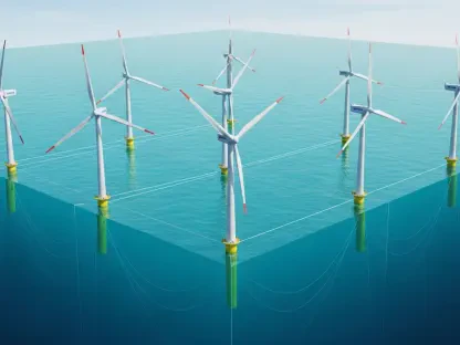
Renewables Readiness: Managing Decentralized Power
The readiness of the smart grid to handle a massive influx of renewable energy is a primary objective of the current technological modernization project. The ArcGIS Utility Network provides the structural foundation required to manage the variable and decentralized nature of wind and solar power, which requires more dynamic balancing than traditional generation. With this system, the utility can predict how renewable inputs will interact with existing loads, allowing for a more stable distribution of green energy across the archipelago. This capability is vital for meeting the nation’s sustainability targets and reducing the overall carbon footprint in the coming years. By enabling more efficient management of distributed energy resources, the utility is not only modernizing its infrastructure but also supporting the economic transition toward a cleaner energy landscape. This resilience is essential for maintaining energy security as global demand for electricity continues to rise and the shift away from fossil fuels accelerates, ensuring that Indonesia remains a leader in sustainable development.
Digital Twin Evolution: Predictive Grid Management
The successful deployment of a centralized geospatial network provided the necessary momentum for Indonesia to finalize its transition toward a fully modernized smart grid. This initiative demonstrated that the challenges of a vast archipelago could be overcome through the strategic application of advanced spatial intelligence and deep enterprise integration. To maintain this progress, the focus moved toward establishing a national center of excellence for geospatial technology to train the next generation of utility professionals in data-driven management. Continuous investment in real-time sensor networks became a priority to further enhance the accuracy of the existing digital twins. The move toward decentralized microgrids was accelerated by the newfound visibility into remote distribution networks, ensuring that even the most isolated communities received reliable power. By prioritizing data integrity and system interoperability, the utility set a global benchmark for how large-scale energy transformations should be handled in complex environments.