
Why Cheboygan Became the Focal Point of a Regional Flood Threat
Spring’s uneasy alliance of rain and melt turned Northern Michigan’s waterways into a single, fast-moving system with one pivotal hinge: the Cheboygan Lock and Dam Complex, where upstream reservoirs met the narrow outlet to Lake Huron and every operational choice had basin-wide consequences. As heavy rain rode in on a stalled front and deep late-winter snowpack let go, flows pressed rivers toward or beyond flood stage, and attention converged on a structure tasked not with stopping water, but passing it safely. The dam’s capacity to move water determined whether neighborhoods, roads, and riparian habitat would withstand the surge.
This timeline sets out the major weather triggers, operational decisions, and community actions that defined the unfolding flood response. It traces how agencies sequenced moves—scaling up discharge capacity, restoring key power links, and aligning messages—to stabilize conditions while staying nimble for late shifts in weather and runoff.
The issue resonates now because this meteorological setup—stalled boundaries, persistent moisture transport, and delayed melt—has become a familiar spring pattern in the Great Lakes. Seeing how Cheboygan’s response evolved gives residents, planners, and operators a clearer playbook for the rest of the season and the next high-water event.
From Snowpack to Pumps: A Chronological Timeline of the Response
Late Winter 2026 – Record Snowfall Sets the Stage
A parade of March storms piled up an abnormally high snowpack across Northern Michigan. Repeated cold snaps preserved that storage well into April, locking in water that would later release quickly. This elevated baseline primed tributaries, tightened margins at lakes and reservoirs, and left dams facing a heavy starting load before the first spring deluge.
Early Spring 2026 – Stalled Front Brings Repeated Rain
A frontal boundary draped across the Great Lakes funneled warm, moist air from the southwest and produced rounds of rain over partially frozen or saturated ground. Gauges across the Cheboygan River Basin trended higher by the day, and forecasters warned that each new batch of rain would intersect with accelerating snowmelt, compounding inflow into mainstem rivers and reservoirs.
April 2026 – Flood Watches Expand, Basins Tip Toward Flood Stage
The National Weather Service issued a broad flood watch for Northern Michigan as rivers neared flood stage. Specific warnings followed for the Cheboygan River Basin and for the Au Sable and Manistee rivers. Local emergency managers stepped up field checks on culverts and crossings, anticipating overtopping and debris jams as water rose and carried spring wood and ice remnants downstream.
April 2026 – State of Emergency Declared at Cheboygan Lock and Dam
Recognizing the complex as a regional choke point, Governor Gretchen Whitmer declared a state of emergency centered on Cheboygan. The order unlocked faster logistics, funding, and interagency coordination, speeding the arrival of specialized crews and equipment to boost outflow and reduce structural loading as levels pressed higher.
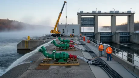
April 2026 – Mechanical Surge to Maximize Discharge Capacity
The Michigan DNR and partners deployed five large pumps to lift water from the reservoir side to the river side, cutting head pressure on the structure within hours. Crews staged a crane to remove select dam gates, further enlarging the path to Lake Huron. In parallel, teams worked with DTE Energy to temporarily restore power to a shuttered hydro station—using industrial wire sourced from Illinois—to run the unit for water movement alone, not for generation.
April 2026 – Parallel Actions on the Au Sable and Manistee
To distribute stress across the region, operators opened flood gates at Mio Dam on the Au Sable and at Tippy Dam on the Manistee. Synchronized with the Cheboygan push, these releases moderated surges, reduced backwater effects, and kept flows controlled and navigable while the front lingered.
April 2026 – Upper Peninsula Vigilance as Snowpack Persists
With 15–30 inches of snow still on the ground in parts of the U.P., Houghton County officials intensified checks on the Sturgeon River, culverts, and gauges. The aim was early detection of runoff pulses that could coincide with new rain, allowing quick interventions before infrastructure felt the full strain.
April 2026 – Public Readiness Without Evacuations
Authorities urged residents between the Cheboygan Dam and Lake Huron to assemble go-bags, follow official alerts, and be prepared to act, while emphasizing that evacuations had not been ordered. A public meeting was scheduled to keep residents and businesses current, balancing vigilance with calm, practical steps.
Through the Week – Sustained Operations and Real-Time Adjustments
With the front holding, agencies committed to continued pumping, staged gate removals, temporary power support for the hydro unit, and 24/7 gauge surveillance. Field teams refined tactics based on live telemetry, aiming to hold upstream levels in check and protect downstream corridors until the weather pattern finally broke.
What Mattered Most: Turning Points, Patterns, and Open Questions
The decisive inflection points were the emergency declaration at Cheboygan, the rapid mechanical expansion of discharge, and the unconventional choice to revive the hydro station purely for throughput. Those moves bought time, eased structural stress, and aligned basin-wide control at a critical window.
Themes emerged: rain-on-snow amplification; the payoff of pre-positioned pumps and cross-utility partnerships; dependence on real-time data for dynamic settings; and public messaging that promotes readiness without needless displacement. Open questions persist about surge-capacity limits at chokepoints, redundant power for water-control assets, and thresholds for shifting from advisory to evacuation in river neighborhoods.
Deeper Context: Regional Nuances, Expert Takes, and Common Misreads
Northern Michigan’s basins do not rise in unison: short-residence lakes pass flow fast, while forested headwaters and lingering U.P. snowpacks delay and then concentrate runoff. When multiple dams near limits, clear prioritization and mutual aid become essential. Experts highlight best practices: pump arrays sized to head differentials, rapid power-restoration playbooks for dormant hydro assets, standardized gate-removal procedures, and expanded gauge networks feeding shared dashboards for multi-agency coordination. Common misreads include assuming dams can “hold back” any flood, underestimating how saturation and snowpack amplify moderate rains, and equating no evacuation order with no risk. The path forward centers on sizing temporary surge capacity, hardening backup power, and refining alert thresholds so that when the next stalled front parks over the lakes, operators act earlier, messages land faster, and rivers move safely where they must.